A complete guide to the nine national parks in California, including the must-sees, must-dos, and where to stay to help you make the most of your time.
The nine national parks in California have more to do and see than anyone can manage in a lifetime, so how do you pick and choose which ones to visit and spend time on?
As someone who has spent my entire career outdoors in countless beautiful places, I’m still continually in awe of our US national parks.
From giant redwoods to sheer cliffs and entire islands, the national parks in the Golden State parks truly have something for everyone.
By the end of this article, you’ll have the full rundown of all nine California national parks, including local tips on how to get the most out of each park.
Note: this post contains affiliate links, which help run this site at no extra cost to you so I can keep providing free travel advice and tips.
California National Parks Map
PS – If you’re looking to hit a few different national parks in California in one trip, don’t miss our guides to planning an epic California national parks road trip and how to use the national park passport and the America the Beautiful Pass.
Get your FREE California Travel Planner – including printable checklists and my favorite two-week itinerary for the state.
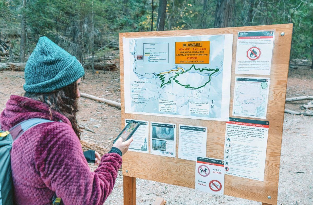
Yosemite National Park
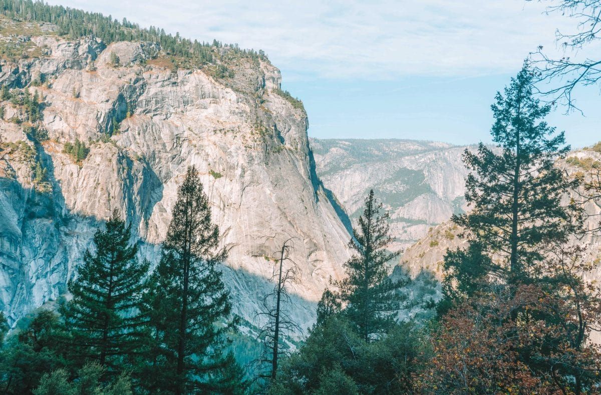
Yosemite National Park is a national gem and certainly one of the best national parks in California.
Situated in the central Sierra Nevada Mountains, the national park encompasses an area roughly the size of Rhode Island.
In addition to the famous Yosemite Valley, Half Dome, and El Capitan, the park includes rugged high-altitude peaks, sparkling lakes, and thousands of acres of forest.
Yosemite National Park is also one of the best national parks near San Francisco, being about a four-hour drive from the city. In fact, it’s one of the most popular weekend trips from the city.
Practical Info
Address: The park doesn’t have one single address. Check out this page for directions.
Entrance fee: $35/vehicle for a 7-day pass
Park hours and phone numbers:
- Park entrances are open 24/7, 365 days a year, with exceptions for natural disasters
- Yosemite Valley Visitor Center: 209-372-0200 (then dial 3, then 5)
- Campground Information: 209-375-9535
- To make campground registrations, you must use recreation.gov
- Check out the park’s Contact Us page to answer all of your questions
- Map of Yosemite National Park
History of Yosemite National park
Congress moved to make the Yosemite region a national park in 1890 to protect the scenic wonders of Yosemite Valley and the Mariposa Grove of Giant Sequoias.
The move was largely inspired by environmentalist John Muir, who lobbied hard to protect special areas of America from further development.
However, before Muir’s arrival on the landscape, it was home to thriving indigenous communities, including the Southern Sierra Miwok.
Top Sights in Yosemite National Park
Yosemite Valley
When most people think of Yosemite, they picture Yosemite Valley, and for good reason. Yosemite Valley is indeed one of the most breathtaking landscapes in the world.
In Yosemite Valley, you can see El Capitan, a famous rock climbing destination, Half Dome, and Yosemite Falls, which is one of the tallest waterfalls in North America.
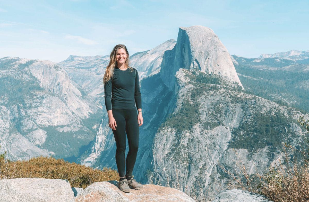
Glacier Point
Glacier Point might be the second most popular area of the park.
Glacier Point is accessible from Highway 41 and takes you to an overlook that gives an incredible view of Yosemite Valley, including a side view of Half Dome.
Mariposa Grove of Giant Sequoias
The Mariposa Grove of Giant Sequoias is the biggest and most famous for a reason. It’s home to around 300 giant sequoias and was part of the original reason the park was established.
Read our complete guides to the best things to do in Yosemite, two days in Yosemite itinerary, and how to experience the Yosemite Firefall.
Where to Stay in Yosemite National Park
Yosemite National Park offers a wide range of places to stay, from campgrounds to tent cabins to historic lodges.
Reservations for hotels and lodges are typically available 366 days in advance and are highly recommended for most of the year.
Read our guide on how to get from San Francisco to Yosemite.
Hotels
The Ahwahnee – The Ahwahnee Hotel is where you should stay if you’re in the mood to splurge. Located in Yosemite Valley, the Ahwahnee is a gorgeous historic hotel with a long list of famous guests. It’s listed on the National Register of Historic Places, features a Harry Potter-esque dining room, bar, sweet shop, and a heated swimming pool. The Ahwahnee is open year-round.
Yosemite Valley Lodge – The Yosemite Valley Lodge is located in Yosemite Valley directly across from Yosemite Falls and offers a more traditional hotel vibe (and has a pool). It’s open year-round.
The Wawona Hotel – The Wawona Hotel is located in the Wawona district of Yosemite, which is near the southern entrance to the park along Highway 41 and is known for its “intimate Victorian charm.” The Wawona Hotel is typically open March-November.
Camping
Camping in California National Parks is often a game won by those who prepare. Don’t expect to find open spots in the campgrounds unless you’ve booked several months in advance.
That said, it’s possible to snag a last-minute spot if someone else cancels their reservation. The only way to snag one of these spots is on recreation.gov.
Check out everything you need to know about camping in Yosemite here.
Curry Village – Curry Village offers some cabins to rent, but they’re most known for their tent cabins. Tent cabins usually have two beds and are more spacious than a traditional tent.
The Pines Campgrounds – The Pines Campgrounds include Lower Pines Campground, Upper Pines Campground, and North Pines Campground. They’re all located adjacent to one another in Yosemite Valley.
Camp 4 – Camp 4 Campground is located at the base of granite cliffs near the Yosemite Valley Lodge. The campground has traditionally been the only first-come, first-served campground in the valley, but in 2021 this changed, and reservations are now required one day in advance. The campground is a go-to for groups of climbers.
Read our guide to the best glamping spots in California.
PS – If you’re looking for camping gear, we have a TON of recommendations (and strong opinions). Check out our guides to the best large family camping tents, 4 person tents, 6 person tents, 8 person tents, pop-up tents, instant tents, 3-room tents, canvas tents, and double camping cots.
How to Get to Yosemite National Park
With four entrances to the park, Yosemite National Park is simply enormous.
Keep in mind that some of the entrances close in the winter due to dangerous road conditions, and tire chains may be required at any time from October-April.
You can always call the information number listed above or check this page for current road conditions.
From the Bay Area/Sacramento
Take I-580 east to I-205 east to Highway 120 east (Manteca) or Highway 140 east (Merced) into Yosemite National Park.
From Reno/Lake Tahoe
June-October: Take US 395 south to Lee Vining; take Highway 120 west into Yosemite National Park (open late May/June through October, depending on conditions)
All Year: Take I-80 or I-50 west to Sacramento; take Highway 99 south to Highway 120 east (Manteca) or Highway 140 east (Merced) into Yosemite National Park.
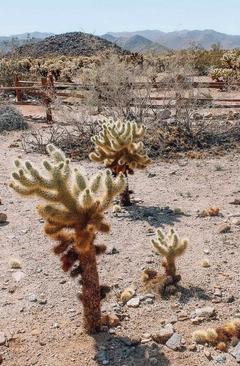
Joshua Tree National Park
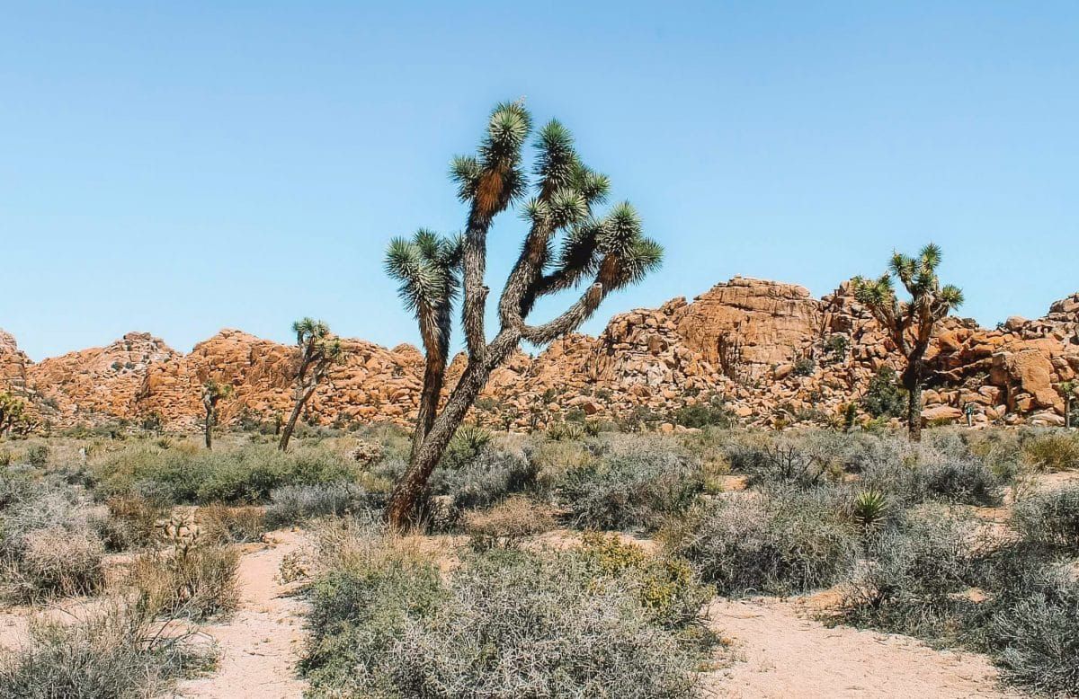
Joshua Tree National Park easily ranks as one of the best national parks near San Diego and the Los Angeles area.
The park is located in southeastern California and is most famous for its iconic Joshua Trees, which are a type of cactus, and as a climbing mecca during the winter.
Practical Info
Address: 74485 National Park Drive, Twentynine Palms, CA 92277-3597
Entrance fee: $30/vehicle for a 7-day pass
Park hours and phone numbers:
- Park entrances are open 24/7, 365 days a year, with exceptions for natural disasters
- 760-367-5500 for general information
- Joshua Tree Visitor Center: This is the main visitor center for those coming from the LA area. Hours of operation change with the season
- Map of Joshua Tree National Park
History of Joshua Tree National Park
Joshua Tree was initially set aside as Joshua Tree National Monument in 1936 in part to protect the desert from cacti poaching.
Before the arrival of European Americans, however, this was the land of the Serrano, Chemehuevi (or Southern Paiutes), and the Cahuilla.
The park is named after the whimsical, wacky-looking Joshua Trees, which dominate some portions of the park.
In addition to protecting plants and animals, the national park encompasses over 700 archeological sites and 88 historic buildings. These are the remnants of a storied gold mining and cattle ranching history.
Joshua Tree became a national park in 1994, and the boundary of the park was expanded to include entire ecological units. This made it into an entire functional ecosystem rather than one broken up by arbitrary borders.
Top Sights in Joshua Tree National Park
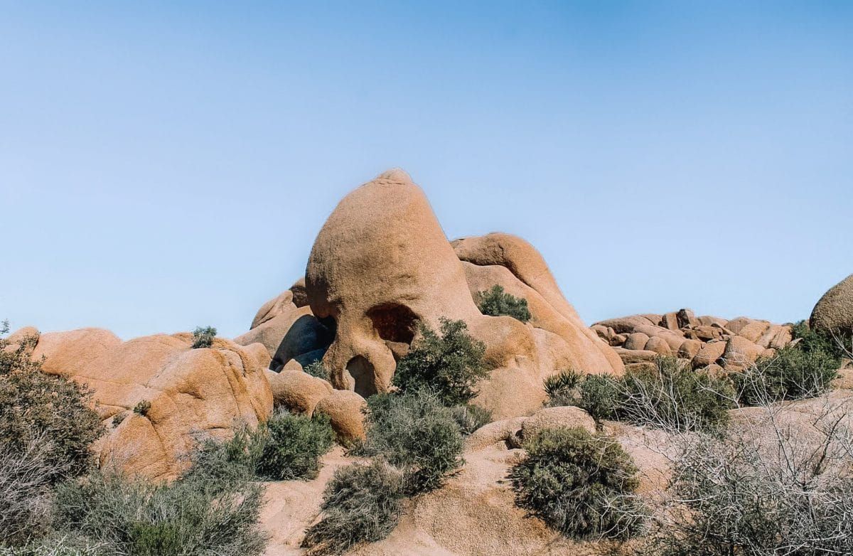
Skull Rock
Skull Rock is a boulder that looks like a skull! You can find it off the side of the road or on an easy 1.8-mile hike that starts across the street from the entrance to the Jumbo Rocks Campground.
Wall Street Mill
The Wall Street Mill is an abandoned gold mine from 1933 built by one of the park’s early immigrants, Bill Keys.
Joshua Tree still has many abandoned mines, but this is one of the easiest to access. You can get there from the Barker Dam Trail.
Keys View
Keys View is a drive-up vista that’s high above most of the park and offers a gorgeous view of the Coachella Valley, especially during sunrise or sunset.
Hidden Valley Nature Trail
The Hidden Valley Nature Trail is another easy one-mile loop that weaves amongst giant boulders. The area was purportedly used by cattle smugglers to keep cows out of view.
Where to Stay in Joshua Tree National Park
Hotels
Joshua Tree Inn – The Joshua Tree Inn is located in Joshua Tree, CA, just six miles from the closest park entrance.
Sacred Sands – This is easily one of the area’s more swanky accommodations.
Camping
Joshua Tree National Park has over 500 campsites, the majority of which are reservable ahead of time.
Joshua Tree campsites typically run from $20-$25/night.
Some campgrounds are almost destinations unto themselves; Jumbo Rocks campground is known for rock climbing opportunities right in the campground!
The busy seasons in Joshua Tree are shoulder seasons (spring and fall) and winter, so definitely book ahead of time if you want to visit then.
You can learn more about Joshua Tree campsites and nearby hotels here.
How to Get to Joshua Tree National Park
Check out directions and a map of how to get to Joshua Tree National Park.
There are three entrances to Joshua Tree National Park, the two most commonly used ones are the following.
From Los Angeles/San Diego:
If you’re coming from Los Angeles or San Diego, the main entrance to Joshua Tree National Park is on the west side of the park off Hwy 62 in the town of Joshua Tree, California. This entrance also has the main visitor center.
From Las Vegas:
The north entrance to Joshua Tree National Park is located in Twentynine Palms, CA, and is also located off Hwy 62.
If you’re coming from Palm Springs, read our road trip guide from Palm Springs to Joshua Tree.
Sequoia and Kings Canyon National Parks
Sequoia and Kings Canyon National Parks are also among the best national parks to visit in California.
They are actually two separate parks that have boundaries adjacent to one another and are managed jointly.
Sequoia and Kings Canyon National Park are located in Central California at the tail-end of the Sierra Nevada Mountains.
Both parks boast stunning old-growth forests and jaw-dropping backcountry High Sierra landscapes.
Despite how busy and popular Sequoia and Kings Canyon National Parks are, I would still rate them as some of the best national parks in California to visit in summer.
This is because of their higher altitude and shady areas that keep things somewhat cool.
Practical Info
Address: 47050 Generals Hwy, Three Rivers, CA 93271 (Foothills Visitor Center)
Entrance fee: $35/vehicle for a 7-day pass
Park hours and phone numbers
- Park entrances are open 24/7, 365 days a year, with exceptions for natural disasters.
- Foothills Visitor Center: (559) 565-3341
- Wilderness/Backcountry Camping Information: (559) 565-3766
- Map of Sequoia and Kings Canyon National Park
History of Sequoia and Kings Canyon National Parks
Before European-American arrival, Sequoia and Kings Canyon National Parks were the homelands of the Mono, Yokuts, Paiute, Western Shoshone, and Tübatulabal. And, like many other tribal communities, they have descendants that still live in the region today.
After the arrival of European-Americans, Sequoia National Park was established in 1890 to protect the giant sequoia trees growing there.
Later in 1940, Kings Canyon National Park was established to protect the glacially-formed high country. Since the formation of Kings Canyon National Park, both have been administered together.
Top Sights in Sequoia and Kings Canyon National Parks
Giant Forest Museum
The Giant Forest Museum in Sequoia National Park is designed to be the starting point for self-guided tours through the Giant Forest of Sequoias.
Big Trees Trail
The Big Trees Trail is a must-do in Sequoia National Park. It’s a 0.8-mile paved trail that features, you guessed it, an extensive collection of giant sequoias!
The trailhead is next to the Giant Forest Museum and is one of the best and easiest hikes in the park.
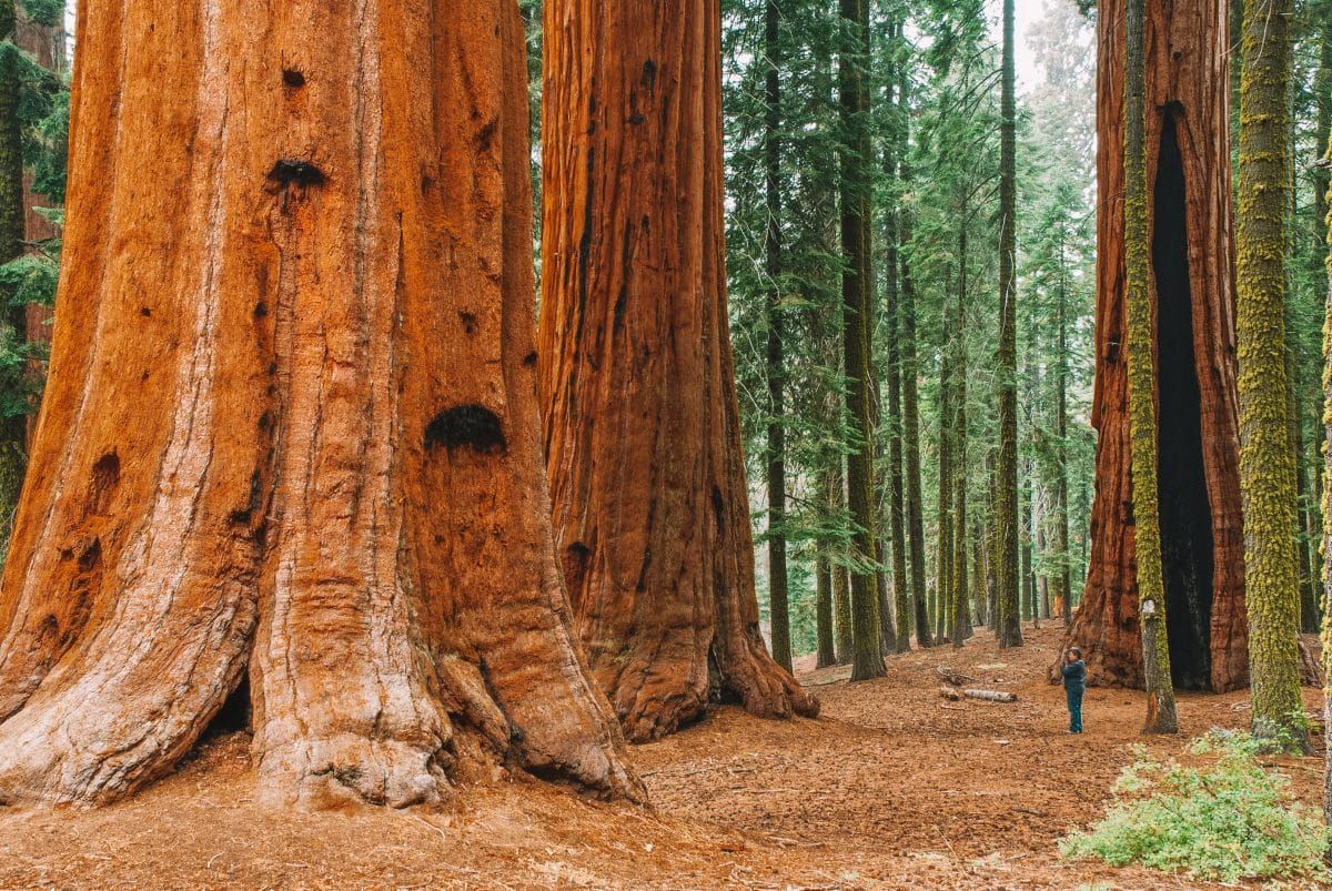
The Giant Forest and General Sherman
In my opinion, no visit to Sequoia and Kings Canyon National Parks would be complete without visiting the Giant Forest, which includes the General Sherman tree.
General Sherman is the biggest tree in the world (yes, I said world) and is located at the north end of the Giant Forest Trail.
Where to Stay in Sequoia and Kings Canyon National Parks
Hotels
Wuksachi Lodge – The Wuksachi Lodge is located in Sequoia National Park and is 4.4 miles from the General Sherman Tree.
John Muir Lodge – The John Muir Lodge is located in Kings Canyon National Park in Giant Grove Village and is close to the Giant Grove.
Grant Grove Cabins – These are rustic cabins located in the Giant Grove, making them another perfect launching spot for adventures.
Camping
Sequoia and Kings Canyon National Parks have 14 total campgrounds. Visit the linked page to get the low-down on all things camping in these parks.
How to Get to Sequoia and Kings Canyon National Parks
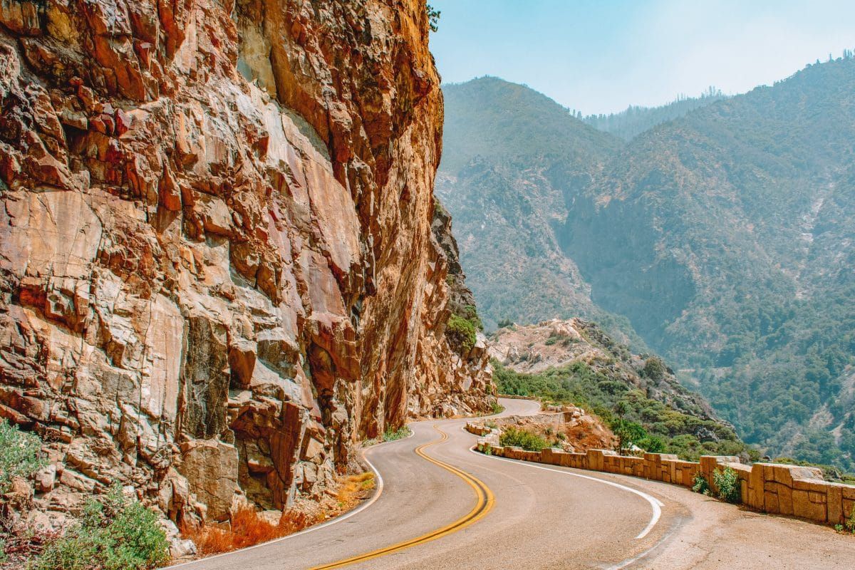
There are two entrances to Sequoia and Kings Canyon National Parks. Both entrance roads are winding and may not be suitable for vehicles over 22-24 ft, like RVs.
Ash Mountain entrance: Take Highway 198 via the town of Three Rivers, CA. Vehicles longer than 24 ft are not recommended past the Foothills Visitor Center, which is stationed at the entrance to the park.
Big Stump entrance: The Big Stump entrance is the only way to drive into King Canyon National Park, and the road may only be open in the summer. Take Highway 180 from the west via Fresno. Highway 180 is less steep and winding than Highway 198 and is better suited for large vehicles.
Death Valley National Park
Death Valley National Park is a land of extremes.
It’s the lowest, hottest, and driest of the national parks. Still, Death Valley is very much alive and home to thriving ecosystems despite the ominous-sounding name.
Because of the hot and dry nature of the park, this is one of the best national parks in California to visit in winter.
The actual valley in Death Valley is flanked on either side by the Panamint Mountains to the west and the Black Mountains to the east.
This not only adds to the diversity of the park but offers incredible viewpoints as well.
Practical Info
Address: There is no exact address for the main visitor center in Death Valley. Map coordinates given by the National Park Service are N 36°27.70, W 116°52.00.
Entrance fee: $20/vehicle for a 7-day pass
Park hours and phone numbers
- Park entrances are open 24/7, 365 days a year, with exceptions for natural disasters
- Furnace Creek Visitor Center: (760) 786-3200
- Backcountry/Wilderness Office: DEVA_Backcountry_Permits@nps.gov
- Map of Death Valley National Park
History of Death Valley National Park
Death Valley was declared a national monument in 1933, and in 1994 the boundaries were expanded and turned into a national park.
Long before this, the Timbisha Shoshone called this landscape home until European immigrants seeking gold arrived in the area.
The park’s name supposedly comes from a “forty-niner” (a European immigrant seeking California gold in 1849) who perished in the hot sun when his wagon got stuck.
The legend purports that his last words were, “Goodbye, Death Valley.”
Top Sights in Death Valley National Park
Badwater Basin
You can’t not go through Badwater Basin if you’re in Death Valley. It’s the lowest point in the western hemisphere and is mainly comprised of a large salt flat.
In hot weather, you can enjoy the basin from your car. In cooler weather, you can walk out onto the flat and see the salt polygons, which are heavily photographed.
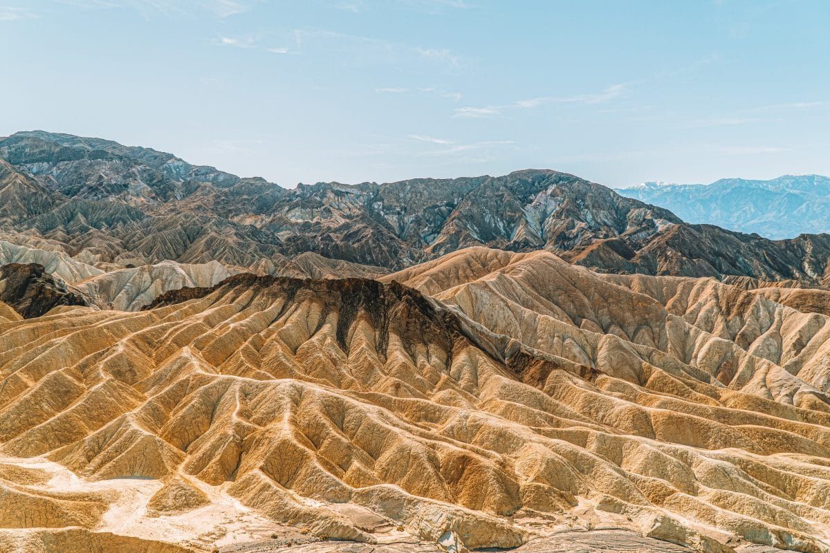
Zabriskie Point
Zabriskie Point is your go-to location for sunrise or sunset views.
The point gives you a panoramic view of the salt flat below and the Panamint Mountains on the other side of the valley.
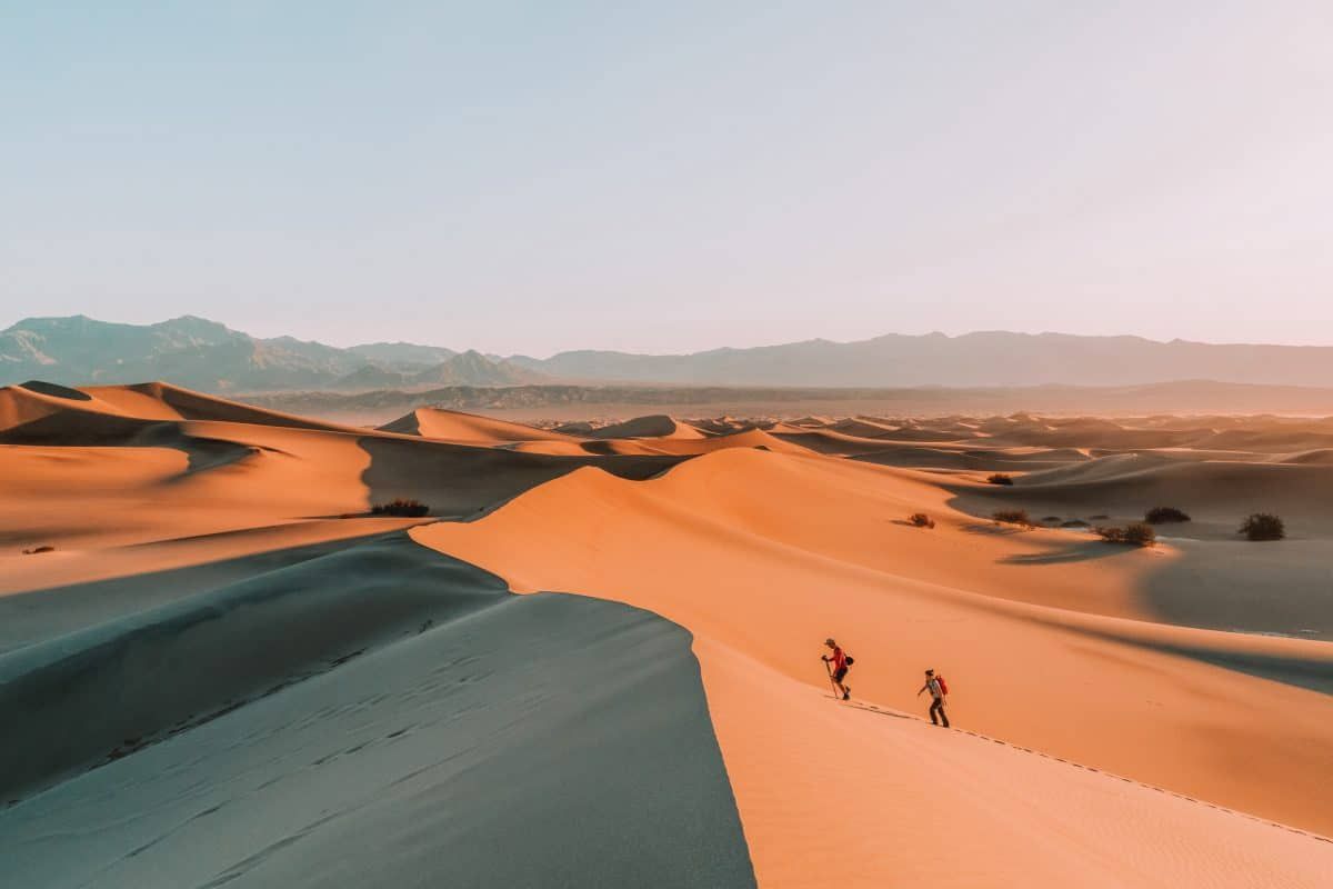
Mesquite Flat Sand Dunes
The Mesquite Flat Sand Dunes are located in the valley of the park and are ringed by mountains on the edge.
The dunes can get up to 100 ft tall and are an excellent spot for dune sledding!
Read our complete guide to the best things to do in Death Valley National Park.
Where to Stay in Death Valley National Park
Hotels
Stovepipe Wells Village – Stovepipe Wells Hotel features a saloon-style bar and restaurant and is located in the Stovepipe Wells area of the park.
The Oasis at Death Valley – This location offers two facilities, the Inn at Death Valley and The Ranch. The Ranch is currently undergoing renovations, but the Inn is operational all year and is a truly luxurious oasis.
Panamint Springs Resort – The Panamint Springs Resort offers hotel lodging, a campground, a gas station, and a general store.
Camping
Death Valley National Park has nine campgrounds, all with different amenities and open seasons.
How to Get to Death Valley National Park
There are three main entrances to get into Death Valley. GPS and cell service are unreliable, so you should always have a map handy before you get in the park.
From Los Angeles (west), the most common entrance is on Highway 395 through Lone Pine.
From Las Vegas (east), there are three ways to enter the park, but the shortest uses California Highway 190.
From the south, you can enter via Highway 190 and Death Valley Junction.
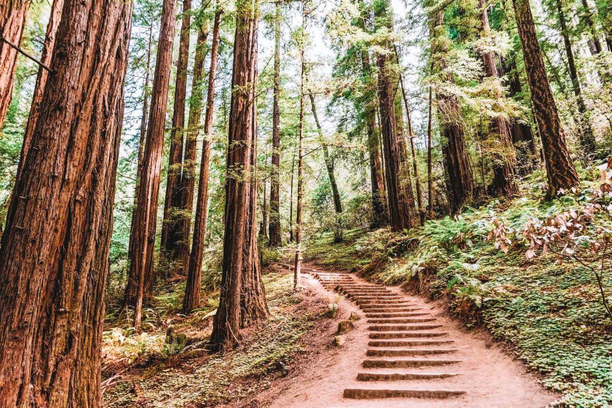
Redwood National and State Parks
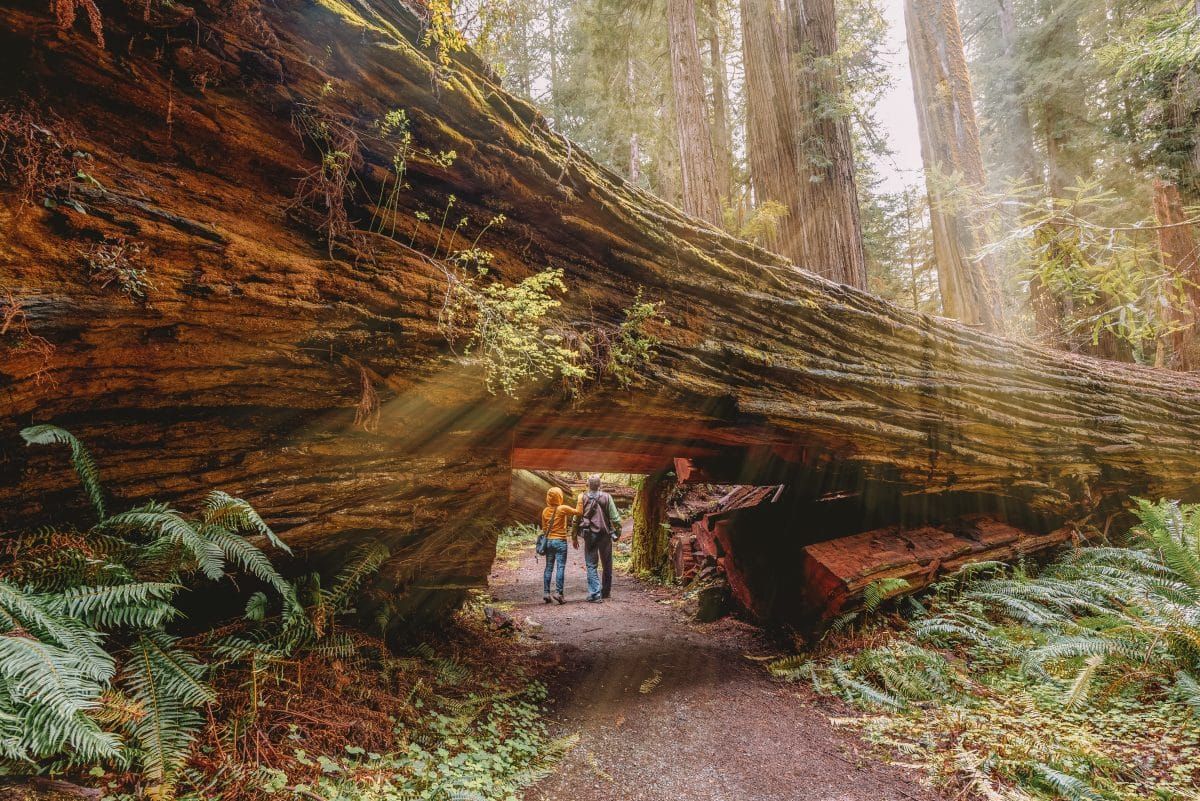
Redwood National and State Parks are located on the Northern California Coast bordering Oregon.
These parks are easily the best redwood parks in California, but they also boast beaches and grasslands.
Redwood National and State Parks is the only national park with the distinction of being jointly run with state parks.
In this case, there are several state parks in this grouping, including Jedediah Smith Redwoods State Park, Del Norte Coast Redwoods State Park, and Prairie Creek Redwoods State Park.
Practical Info
Address: Located along U.S. Highway 101 between Orick, CA and Crescent City, CA.
Entrance fee: $0 for entering Redwood National Park but $5 day-use fee for the three state parks.
Park hours and phone numbers
- Park entrances are open 24/7, 365 days a year, with exceptions for natural disasters
- You can plan your visit to Redwood National and State Parks here
- Five visitor centers include the Hiouchi Visitor Center, Prairie Creek Visitor Center, Thomas H. Kuchel, Jedediah Smith Visitor Center, and the Crescent City Information Center
- Call (707) 464-6101 to be directed to any of the visitor centers
- Map of Redwood National and State Parks
History of Redwood National and State Parks
Redwood National and State Parks now sits on land that was occupied by large, long-standing, and complex indigenous communities that thrived on the area’s natural resources.
The idea of distinct “tribes” may not accurately describe the complexity of the native communities before 1850, but today the most prominent existing languages include Yoruk, Hupa, Karuk, and Tolowa.
After the Gold Rush of 1850, European settlers in need of timber for homes and buildings began to put pressure on the then extensive redwood forests. When transportation technology increased, so did the timber harvests.
By the early 1900s, citizens concerned for the dwindling big tree ecosystems rallied together to protect portions of the area by forming Jedediah Smith, Prairie Creek, and Del Norte Coast State Parks.
Even after establishing the state parks, logging continued on private land. It wasn’t until 1968 that Redwood National Park was established to protect some of the remaining unharvested redwood stands.
Top Sights in Redwood National and State Parks
Lady Bird Johnson Grove
Lady Bird Johnson Grove is a 1.5-mile loop trail located 10 miles north of Orick, CA, and features a self-guided tour of giant redwood trees. The grove is named after first lady Lady Bird Johnson, whose trademark projects were environmental.
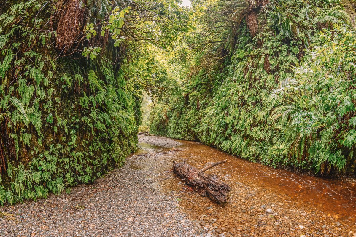
Fern Canyon
Located in Prairie Creek Redwoods State Park, Fern Canyon is a very popular one-mile loop trail where you walk through a steep-sided canyon that’s covered with ferns.
Stout Grove
Located in Jedediah Smith Redwoods State Park, the Stout Grove of redwoods is a must-see simply because it’s stunningly beautiful.
Where to Stay in Redwood National and State Parks
There are a small number of cabins to rent in Redwood National and State Parks.
Otherwise, if you’re looking for a hotel, several nearby towns have the entire gamut of lodging options.
Hotels
Cabins at Jedediah Smith Redwoods State Park and Prairie Creek Redwoods State Park are ADA accessible and have basic amenities.
Camping
There are four developed campgrounds in Redwood National and State Parks. All four of them are located within the various state parks.
Unlike most campground reservations, which are made through recreation.gov, you’ll need to use reservecalifornia.com to make these reservations.
How to Get to Redwood National and State Parks
Redwood National and State Parks are located along U.S. 101 between Orick, CA, and Crescent City, CA.
There’s no formal entrance station to this park, and it’s possible to drive right through it without even realizing you entered a national park.
Several scenic drives provide access to different areas of the parks.
Lassen Volcanic National Park
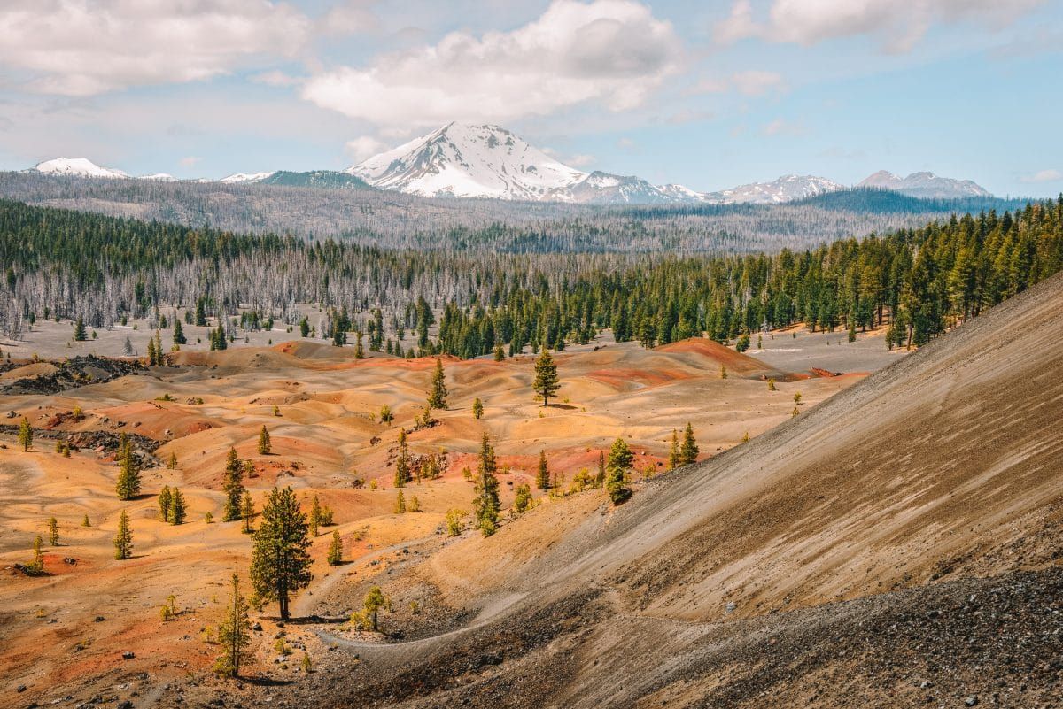
Lassen Volcanic National Park is one of the best national parks in Northern California, especially if you’re a geology nerd like me.
Lassen is located in the northern portion of the Sierra Nevada, just below the Oregon border.
The park features all four types of volcanoes as well as fumaroles (volcanic vents that let gas escape), bubbling mud pots, and steaming pools.
Lassen National Park also has 150 miles of hiking trails, so there’s a lot to do here besides gawking at rock formations.
Practical Info
Address: 21820 Lassen National Park Hwy, Mineral, CA 96063 (Kohm Yah-mah-nee Visitor Center, Southwest entrance)
Entrance fee: $30/vehicle for a 7-day pass. $10/vehicle in winter
Park hours and phone numbers
- Park entrances are open 24/7, 365 days a year, with exceptions for natural disasters
- Kohm Yah-mah-nee Visitor Center: (530) 595-4480
- Map of Lassen Volcanic National Park
History of Lassen Volcanic National Park
Long before the arrival of Peter Lassen, after whom the park is named, Lassen was the seasonal homeland of the Atsugewi, Yana, Maidu, and Yahi tribes. They primarily occupied the land during the summer months.
In 1916, after the arrival of European Americans, Lassen was set aside to protect the hydrothermal and volcanic curiosities like boiling mud pots.
Top Sights in Lassen Volcanic National Park
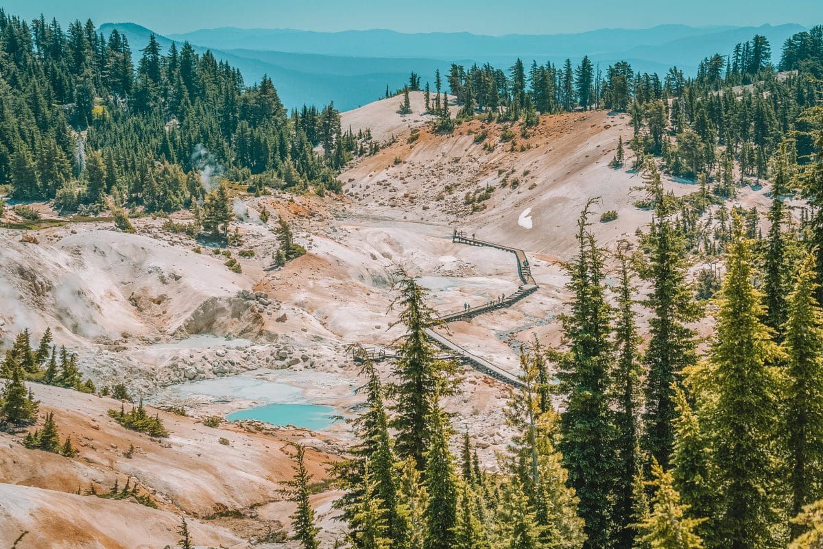
Bumpass Hell
Bumpass Hell is the largest hydrothermal area of the park and features steamy pools. You can hike around on wooden boardwalks that make up a three-mile loop.
Lassen Peak
Lassen Peak, or Mount Lassen, is the southernmost active volcano in the Cascade Range (cool!). The hike to the top is five miles round trip and is rated strenuous.
Where to Stay in Lassen Volcanic National Park
Hotels
Drakesbad Guest Ranch – This is the only hotel-style lodging inside the park.
Camping
Lassen Volcanic National Park has seven campgrounds with variable amenities and open seasons.
How to Get to Lassen Volcanic National Park
Lassen Volcanic National Park is located in Northern California near Redding. Check out this page for more detailed directions.
Both the north and south sides of the park can be accessed from Hwy 89.
Pinnacles National Park
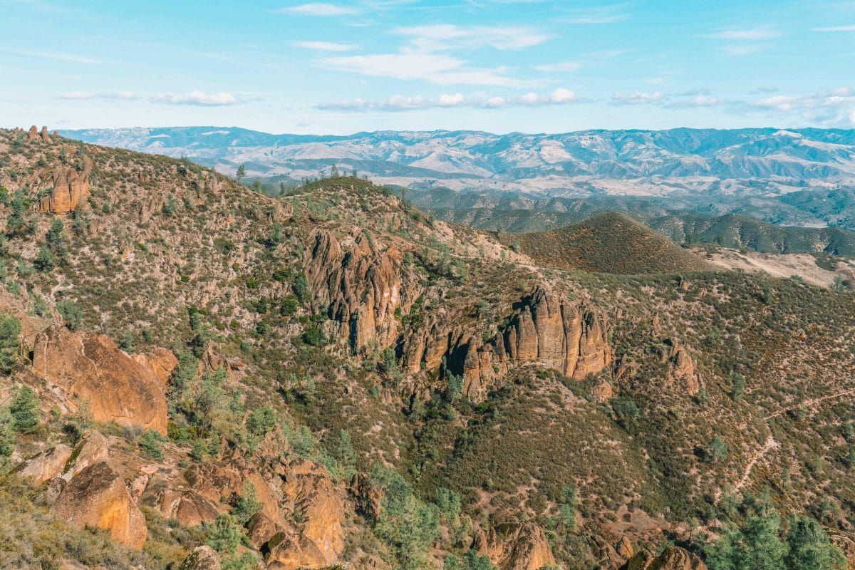
Pinnacles National Park protects the unusual and beautiful volcanic spires and talus caves formed from an eruption 23 million years ago.
Today the park is a mecca for climbers and a haven for the endangered California Condor, known to nest in the park.
Practical Info
Address: GPS coordinates for Pinnacles Visitor Center 36.493545, -121.146646
Entrance fee: $30/vehicle for a 7-day pass
Park hours and phone numbers
- Park entrances are open 24/7, 365 days a year, with exceptions for natural disasters. In the winter, the west side of the park may only be open from 7:30 am-8 pm.
- Pinnacles Visitor Center (east side of the park): (831) 389-4485
- Chaparral Visitor Contact Station (west side of the park): (831) 389-4427
- Campground information: (831) 200-1722
- Map of Pinnacles National Park
History of Pinnacles National Park
Volcanic activity 23 million years ago formed the rock spires and caves of Pinnacles National Park.
As with all the national parks in California, the area of Pinnacles National Park supported thriving indigenous cultures before the arrival of Spaniards in the late 1700s, including but not limited to ancestors of the Amah Mutsun tribe.
In the 1890s, an American man from Michigan settled in the area. When he realized how beautiful the rock formations were, he began acting as a resident caretaker.
In 1908, he successfully petitioned Theodore Roosevelt to make Pinnacles a national monument.
In 2013 under the Obama administration, Pinnacles National Monument became a national park.
Top Sights in Pinnacles National Park
Bear Gulch Cave Trail
The Bear Gulch Cave Trail is cool because you walk through enormous boulders, a forest, and two caves to eventually end up at a reservoir.
Bear Gulch Cave is particularly special because it hosts the largest group of Townsend’s big-eared bats in the state. This is an easy 1.5-mile hike.
Note: To let the endangered bats rest undisturbed, some of the cave may be blocked off for part of the year, so you’ll want to check the NPS website ahead of time.
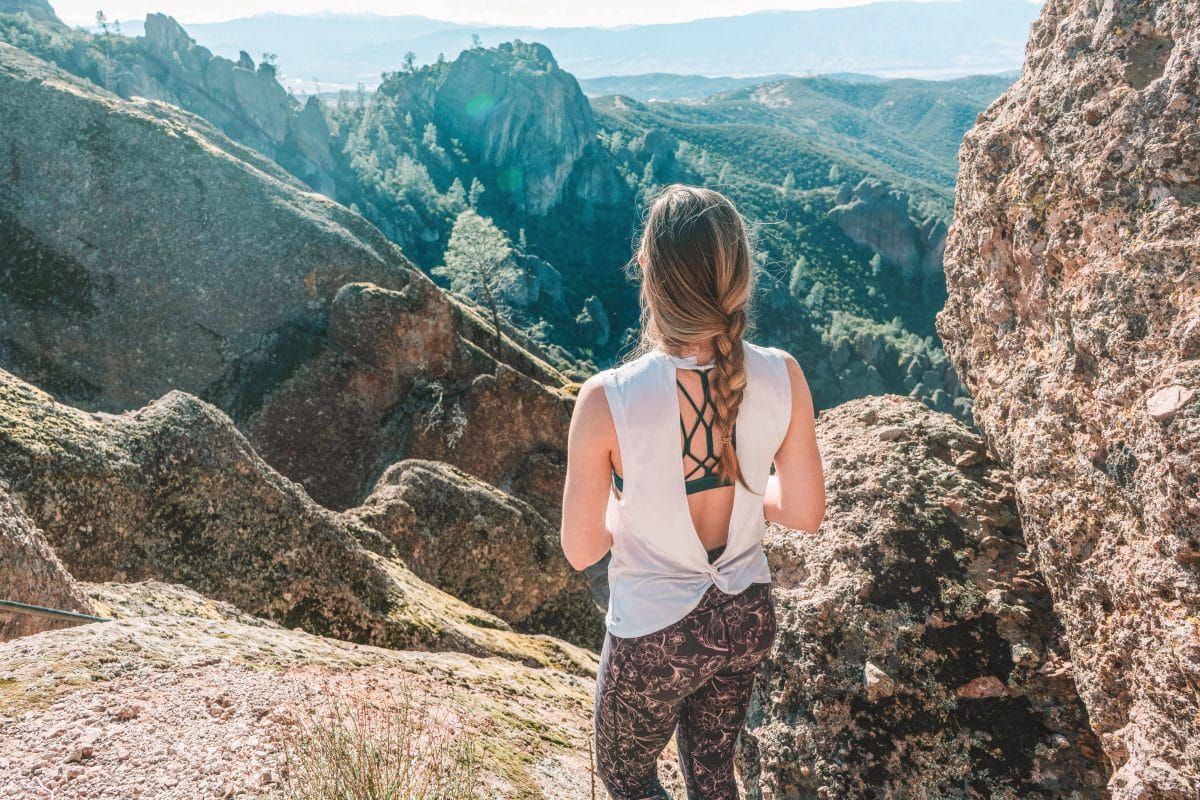
High Peaks Trail
The High Peaks Trail is a strenuous 6.7-mile hike that leaves from the Bear Gulch Day Use Area, the starting point for several hiking trails.
The trail, while strenuous, is gorgeous, with views that overlook the rest of the park.
Balconies Cave Trail
The Balconies Cave Trail is a heavily trafficked 2.6-mile loop that takes you through the dark and twisty Balconies Cave, one of the park’s many talus caves.
Be sure to bring a headlamp! The trail is rated as moderate.
Read our complete guide to Pinnacles National Park.
Where to Stay in Pinnacles National Park
Pinnacles National Park only offers one campground within the park itself, but there are numerous options in the nearby towns. Here are a few of my picks!
Hotels
Inn at the Pinnacles – This is a charming villa-style bed and breakfast five minutes from Pinnacles.
Keefer’s Inn – Keefer’s Inn in King City, CA is about a 40-minute drive to Pinnacles National Park.
Camping
Pinnacles Campground – This is the only campground at Pinnacles and is accessed from the east side of the park.
How to Get to Pinnacles National Park
Like many other national parks and wild places, using GPS to navigate to or around them can be tricky. This is certainly the case with Pinnacles.
The park recommends using the following GPS coordinates to navigate to the park:
East side of the park (Pinnacles Visitor Center): 36.493545, -121.146646
West side of the park (Pinnacles Visitor Contact Station): 36.477700, -121.226136
For more information and driving directions, click here.
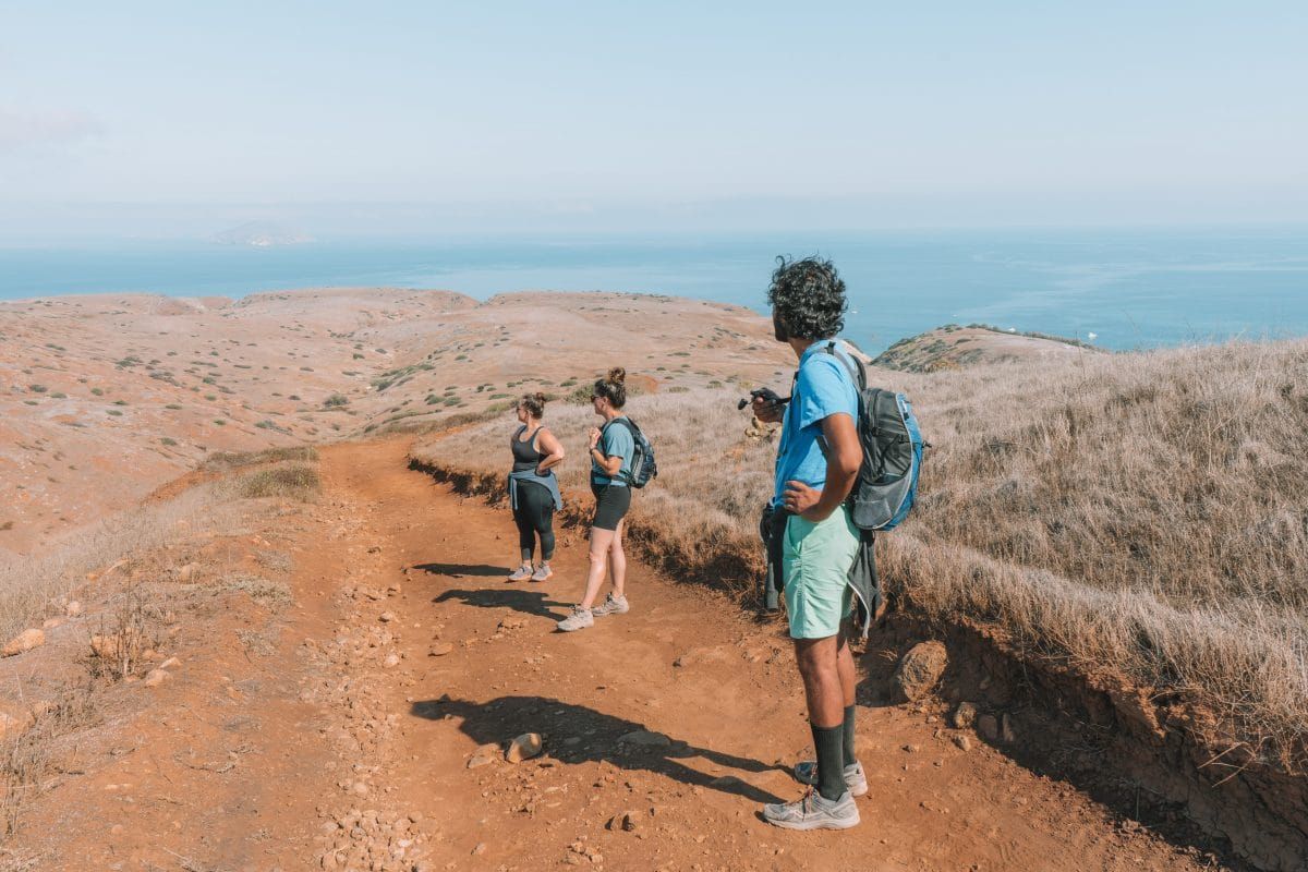
Channel Islands National Park
Practical Info
Channel Islands National Park is one of the best national parks near Los Angeles and offers a quiet and wild juxtaposition to the LA metroplex.
The national park comprises five islands: Anacapa, Santa Cruz, Santa Barbara, and the two smaller Santa Rosa and San Miguel.
The waters around the islands are known for their oceanic diversity, and the islands themselves are home to an island fox species that live nowhere else on earth.
Address: Channel Islands National Park is located in the Pacific Ocean off the coast of Los Angeles. See below for mainland visitor center addresses.
Entrance fee: No entrance fee, but you must pay for a ferry ticket to access the islands. Ferry costs vary depending on if you’re doing a day trip or multiple days, and there’s tiered pricing for children, adults, and seniors. Prices range from about $45-$168 per person.
Park hours and phone numbers
- Park entrances are open 24/7, 365 days a year, with exceptions for natural disasters
- The Robert J. Lagomarsino Visitor Center: 1901 Spinnaker Drive, Ventura, CA 93001 Phone: (805) 658-5730
- Outdoors Santa Barbara Visitor Center: 113 Harbor Way 4th Floor, Santa Barbara, CA 93109. Phone: (805) 884-1475
- There are visitor centers on Santa Barbara Island, Anacapa Island, and at Scorpion Ranch on Santa Cruz Island. There are also contact stations on San Miguel and Santa Rosa Island.
- Camping Information: (877) 444-6777
- Map of Channel Islands National Park
History of Channel Islands National Park
Each of the islands in the Channel Islands has a unique history.
Indigenous Chumash people lived there for thousands of years before European settlers began farming sheep and cattle on the islands.
Two of the islands were turned into a national monument in 1938 by Franklin D. Roosevelt, and in 1980, all five islands were set aside and protected as national parks.
Top Sights in Channel Islands National Park
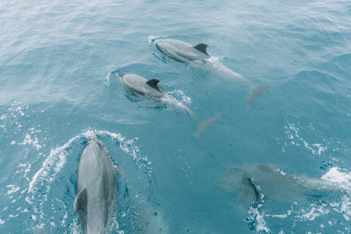
Whale and Dolphin Watching
The ocean currents around the Channel Islands make it a hotspot for ocean diversity.
In addition to seeing whales and dolphins on your way out to the islands, you can also just book a whale watching tour through Island Packers, where their staff will help you pick out whales on the horizon. Yes, please!
Kayaking
The Channel Islands is one of the few parks with fantastic sea kayaking opportunities, so, of course, I have to include that here.
Scorpion Cove on Santa Cruz Island is a great place to kayak. You can also take part in a guided tour through sea caves with the Channel Islands Adventure Company.
Where to Stay in Channel Islands National Park
Hotels
There are no hotels on any of the islands that make up Channel Islands National Park.
However, if you’re making a day trip, you should have no trouble finding plenty of accommodation options in the Ventura/Oxnard area where the Island Packers ferries depart.
Camping
There’s a campground on each of the five islands and some backcountry camping options on Santa Cruz and Santa Rosa Islands.
All reservations are made through Recreation.gov.
How to Get to Channel Islands National Park
While the mainland visitor centers are accessible by vehicle, the islands can only be accessed via Island Packers ferries or by private boat.
Island Packers’ rates vary depending on age group, which island you’re visiting, and whether the trip is overnight or not.
Adult Anacapa and Santa Cruz overnight tickets are around $80/ticket, while San Miguel, Santa Barbara, and Santa Rosa are $120-$168.
Once on the islands, there’s no motorized transportation; you’ve gotta hoof it yourself or use a kayak you also brought yourself.
FAQs About California National Parks
What are the best national parks to visit in California?
The best national parks to visit in California depend on what you’re looking for.
If you want jaw-dropping vistas and don’t mind crowds, Yosemite is your park. If you’re looking for a quieter natural experience, the backcountry of Kings Canyon might be for you.
What is the least visited national park in California?
Channel Islands National Park is one of the least visited national parks in California. The islands see just under 500,000 visitors a year, all of whom must book a ferry ride to the islands.
How many national parks are in Southern California?
There are two national parks in Southern California; Joshua Tree National Park and Channel Islands National Park. Death Valley is also nearby as a southeastern California national park.
What is the largest national park in California?
Death Valley is the largest national park in California, with over three million acres of land. By comparison, Yosemite National Park has around 800,000 acres of land.
What is the most beautiful park in California?
While many people may look to the most popular national parks in California as the most beautiful, remember that beauty is in the eye of the beholder.
Why is Lake Tahoe not a national park?
There have been attempts in the past to make Lake Tahoe a national park; however, each has fallen through.
Lake Tahoe is a highly developed area with hundreds to thousands of private landowners and businesspeople who would have to forfeit their land and businesses to make the lake a national park.
List of National Monuments in California
If you’re looking for even more beautiful and protected natural areas besides the national parks, here’s a list of California national monuments.
- Berryessa Snow Mountain National Monument
- Cabrillo National Monument
- California Coastal National Monument
- Carrizo Plains National Monument
- Castle Mountain National Monument
- Cesar Chavez National Monument
- Devils Postpile National Monument
- Fort Ord National Monument
- Giant Sequoia National Monument
- Lava Beds National Monument
- Mojave Trails National Monument
- Muir Woods National Monument
- San Gabriel Mountains National Monument
- Santa Rosa and San Jacinto National Monument
- Tule Lake National Monument
Looking for more parks in California? Here’s our complete bucket list of California State Parks.
Get your FREE California Travel Planner – including printable checklists and my favorite two-week itinerary for the state.
ABOUT THE AUTHOR

Mimi McFadden
Founder & Editor-In-Chief
Mimi McFadden initially started The Atlas Heart in 2013 to write about her adventures abroad. But since 2019, The Atlas Heart has become a love letter to the Golden State. Mimi enjoys sharing her first-hand knowledge and expertise with the places she knows so well and making the most comprehensive travel guides possible. When she’s not hiking and exploring new places in California, she loves to travel abroad, read in her cozy chaise lounge, play basketball, and connect with friends and family over board games. Over her 28 years in California, she has lived in Santa Cruz (18 years), San Diego (5 years), and the San Francisco Bay Area (5 years), where she currently resides.
Looking for more California travel inspiration? Check out these related posts below!
Places to See Redwoods Near San Francisco
Best Places to Spend Christmas in California
Best Sunflower Fields in California
Romantic Getaways in California
Best Places for Snow in California
Best Bay Area Hikes Near San Francisco
Ultimate Pacific Coast Highway Road Trip Guide
Magical Flower Fields in California
Pin this image for future reference

