Short on time? Our pick for the best handheld GPS device for hiking and backpacking is the Garmin GPSMAP 67i.
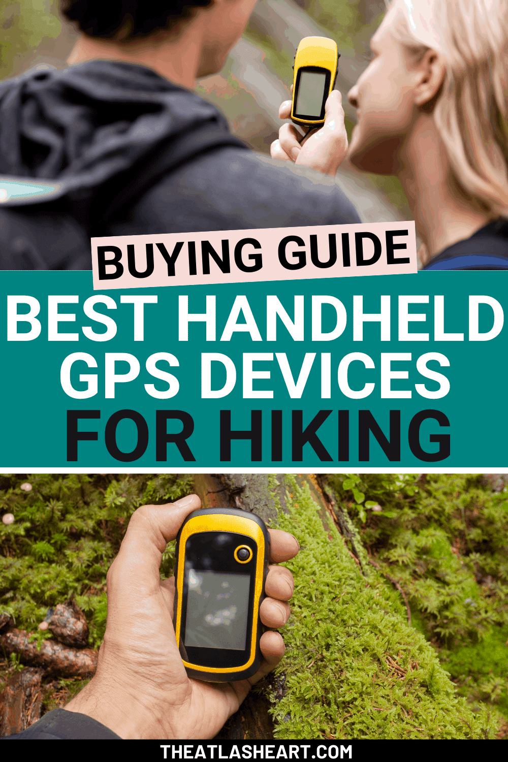
The best handheld GPS devices for hiking and backpacking – whether you’re a seasoned hiker or just starting out.
For the longest time, I tried to use Google Maps when hiking through more rugged terrain.
Inevitably, I’d go deep enough into the forest or high enough on a switchback that my Google Maps app would suddenly “lose connection,” or my pre-downloaded maps wouldn’t load properly.
Cue the anxiety and frustration as I spun around in circles, raising my phone high and praying to the cellphone tower gods that they would send me a signal as confirmation of their existence.
As I started hiking more seriously and investing more in my hiking gear, my research into handheld GPS devices took me down a rabbit hole.
First of all, the technology behind GPS is genuinely mind-blowing.
Did you know that 33 satellites orbiting Earth are nearly single-handedly responsible for humans not needing to read maps anymore?
Now, companies like Garmin have managed to condense all of that technological marvel into a compact handheld that can pinpoint your location anywhere in the world.
It’s mind-blowing how far technology for outdoor gear has come.
And that’s why, if you’re a regular hiker (especially one who explores the backcountry), it’s a good idea to think about investing in a solid GPS device.
In this post, I’ll share my picks for the best hiking GPS devices and what to look for before you purchase one.
Note: this post contains affiliate links, which help run this site at no extra cost to you so I can keep providing free travel advice and tips.

Short on time? Here’s a Quick Look at My Recommendations
- Best Handheld GPS for Hiking and Backpacking – Garmin GPSMAP 67i
- Best Handheld GPS With Satellite Communication – Garmin in Reach Explorer+
- Best Handheld GPS Under $200 – Garmin eTrex 22x
- Best Handheld GPS with a Touchscreen – Garmin Montana 680t
- Best Handheld GPS for Beginners – Garmin Oregon 700
- Best Handheld GPS for Geocaching and Hiking – Garmin eTrex 10
- Best GPS Watch for Hiking – Garmin Instinct 2
- Best GPS Watch for Running and Hiking – Garmin Forerunner 245
Do I Need a Handheld GPS for Hiking?
Even the most seasoned of hikers can get lost on the trail, and you don’t want to be caught in a worst-case scenario where you’re running out of supplies, potentially injured, and far from any sort of help.
So the short answer is: it depends, but owning a handheld global positioning system doesn’t hurt.
Should I Get a Handheld GPS Device or a GPS Watch for Hiking?
Both are great options, it just depends on what you’re looking for.
If you want to keep your hands free, a GPS watch can be ideal.
But a handheld device will usually give you a more detailed overview of the surrounding terrain.
How Do You Use a Handheld GPS?
Handheld GPS devices are straightforward to use once you understand the mechanics.
Here are the steps to create a route on your GPS device:
First, you want to pinpoint your current location via trilateration, which uses at least three different satellites to pinpoint your location.
Second, you want to use a map to find the coordinates of your endpoint.
Plug in those coordinates and the endpoint should appear on your GPS screen.
Finally, you can load a map into your GPS and mark waypoints between your start point and endpoint.
That way, your device can provide the bearing and distance to a waypoint – like following a trail of breadcrumbs.
You can also lay track points, display trip data, use an electronic compass, and more.
Can I Use My Phone GPS for Hiking Instead?
This question is often asked because why wouldn’t you just use your Google Maps app instead of investing in a pricey device?
While your phone GPS might be okay closer to the city, it isn’t an ideal option if you’re doing longer hikes in the wilderness.
Your phone is not as durable as a GPS device (e.g. you’re in trouble if you get rained on, the phone lands in mud, or you crack its screen) and the signal gets weaker the further you hike away from cell towers.
Overall, a phone GPS is fine for casual, short hikes as long as you keep the above points in mind about its durability and reliability.
But for anything more than short hikes somewhat near urban areas, you’ll want to invest in a good GPS for hiking.

These are the best GPS phone apps I’d recommend if you’re not quite ready to invest in pricier hiking gear.
Best GPS Apps for Hiking
For $19.99/year, you can download superior trail maps and record your hikes to either your Android or iPhone.
Their most recent maps offer a level of detail, with contour and shading, that you’d be hard-pressed to find in other GPS apps.
The GPS app owned by outdoors retail giant REI, the Hiking Project app not only offers maps of over 35,000 trails, but it also provides key data and waypoints so hikers know exactly where they need to go.
This is a good GPS app option for either iPhone or Android.
A free GPS app, Maps.ME has detailed maps from all over the world.
Not only can you download those maps and use them offline, but they often have a lot more detail in terms of points-of-interests compared to other maps.
One of the best GPS apps for Android, this app comes in several pricing tiers, from free to $29.99.
Depending on how you like to kit out your app, you pay extra to gain access to detailed offline topographic maps, add favorite spots, and view different types of trails.
If you combined all the different maps from Google Maps, Waze, MapQuest, and more – you’d get Polaris GPS Navigation.
Polaris features multiple coordinate formats, trail recording, and the ability to put in your own waypoints.
This is another good GPS app for Android.
Read our complete guide to the best hiking apps.
Do Handheld GPS Devices Need Internet?
You don’t need the Internet for global positioning systems.
All your device needs is clear access to the sky where the satellites are.
Do Handheld GPS Devices Work Without Phone Signal?
Yes, they will work without a phone signal.
Unlike smartphones that rely on cell towers, handheld GPS devices rely on satellites orbiting the Earth.
The signal might drop depending on where you are, but you generally won’t lose GPS signal completely.
Do Handheld GPS Devices Have Maps?
Some GPS devices will have pre-loaded maps, but many will also give you the option of post-loading maps.
There are plenty of free maps available for download if you don’t want to go through the trouble of buying them.
NOTE: If you buy a Garmin GPS device, they will add a “t” at the end of their model name to denote pre-loaded maps.
Can I Just Rent a GPS Device for Hiking?
GPS devices can be pricey, so if you don’t have the budget to buy your own right now, you can rent one for a hiking trip at an affordable price.
Sites like lowergear allow you to rent GPS devices in set intervals for however long your trip is.
Is a Handheld GPS Worth It?
Hiking is an incredible hobby, but it also comes with risks.
As I said earlier, using a GPS app on your phone is convenient but it won’t perform the same as a handheld GPS (e.g. it’s not weatherproof, needs reliable cell signal to navigate, etc).
While the price of a handheld GPS can be intimidating, it is a worthwhile investment if you plan to do a decent amount of hiking.
If you want to go hiking in the backcountry, you’ll need some sort of compass and map at the very least.
A handheld GPS device is essentially an electronic compass that works on top of a map.
Additionally, it has bells and whistles to make hiking a fun, challenging, and safe experience for all.
What to Look for in a Handheld GPS

Reception
Reception is the most important factor to consider in a GPS device – after all, that’s why you’re buying one.
It’s expected that you should lose some signal if you’re trekking through a heavily forested area, but making sure your device can track your location at consistent intervals in different types of terrain is paramount.
Speed
Sometimes, it can be nerve-wracking to keep looking at your GPS device to find that your position on the map hasn’t changed.
Sometimes it has to do with poor reception, but there are also GPS devices that simply struggle with processing signals quickly and accurately.
If you don’t feel comfortable without a GPS device updating or responding frequently, then you should prioritize speed when buying one.
Size & Weight
Because of their increased durability and hardware compared to a phone, a handheld GPS device can weigh anywhere between 3-9 oz (between a deck of cards and a chubby hamster).
While that doesn’t sound particularly heavy, holding onto it for long periods can get tiring.
Display
Even though handheld GPS screens are not known for their display capabilities, there are some in the market that offer a well-illuminated interface, great visibility in direct sunlight, and even camera functionality.
Some even offer touchscreen functionality, so it doesn’t feel too far off from a smartphone.
Electronic or Differential Compass
Depending on your preference, you might either want to read an electronic or differential (non-electronic) compass.
If you want to be able to tell which direction you’re facing while standing still, go with an electronic compass.
If you don’t mind walking a bit to establish the direction of travel, then a differential compass is always a reliable choice – and you won’t have to recalibrate it.
How Easy It Is To Use
Phones today have made their bread and butter from being easy to use, addictively so.
So when you see a GPS device, you might be a little intimidated by their more robust design.
But things like having physical buttons can make handling a device easier, especially if you’re wearing gloves or exposed to rain/snow.
Many beginner devices have simple UIs and straightforward functionality for the basics.
Once you’ve figured out exactly what activity you’re using your device for (mountaineering, walking through dim forests, etc), you can buy one that is more tailored for your type of adventure.
Features & Versatility
Waypoints
Waypoints are a set of coordinates that can serve as milestones along the trail, and which you can be stored on your GPS device.
Depending on the internal memory of your device, you can store anywhere from 50o to 10,000 or more waypoints.
And even though GPS devices have waypoint limits, some devices allow you to import point-of-interest (POI) databases separate from waypoints as well.
Geocaching
A GPS device is perfect for tracking down a geocache since geocaching is all about playing with GPS.
There are some GPS devices with features built specifically for geocaching, like the Garmin eTrex 10, which saves you time from having to manually input coordinates.
Barometric Altimeter
If you’re doing high-altitude hiking, a handheld GPS device can also support barometric altimeter functionality for that extra boost of elevation accuracy.
A barometric altimeter is an instrument used to measure the altimeter of an object at a fixed level.
In this case, a barometric capsule is linked to a capsule that moves across a dial depending on the barometric pressure.
Media
You really won’t need a smartphone if you get a handheld GPS device with media functions.
To document your hike, you can just use it to take pictures of waypoints to share with your friends and family or videos of the breathtaking landscape.
You can also sometimes record voice or sound memos to fully capture your journey.
Wireless Capability
While GPS devices can function perfectly well without WiFi or an Internet signal, some devices do have wireless capability.
With wireless capability, you can share files with other compatible devices and sometimes even receive text notifications if you’ve synced your device to your phone.
8 Best GPS Devices for Hiking and Backpacking
#1 Garmin GPSMAP 67i
Best Handheld GPS for Hiking and Backpacking
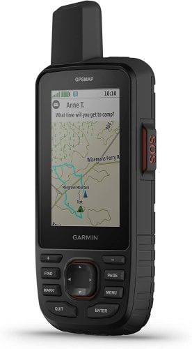
Display Size: 3 inches
Weight: 8.1 ounces
Battery Life: Up to 180 hours in GPS mode
Memory: 16 GB
Number of Waypoints: 10,000
Touchscreen: None
The Garmin GPSMAP 67i is one of the best GPS devices for hiking because of its highly accurate readings and its built-in topo maps.
The topo maps feature plenty of routes for cycling and hiking in North America, allowing you to readily explore different trails on a whim.
It also uses a 3-axis compass and barometric altimeter, on top of a high-sensitivity receiver, and multi-GNSS support to make sure that you get the most accurate readings possible.
The GPSMAP 66i receives signals in myriad orientations and frequencies when GNSS signals might not normally reach you.
It’s easily one of the most accurate handheld GPS devices out there.
The Garmin GPSMAP 67i also allows you to log up to 10,000 waypoints and 250 tracks.
All of these features, plus the iReach and 10-minute tracking make me feel safe. Even if my phone is out of service, I could send out an S.O.S. or my family could check that I’m on the planned route.
As for design, its water-resistant body and buttons make the GPSMAP 67i ideal for hiking in most weather.
And it’s the same price as the previous Garmin GPSMAP 66i model, which has less than half the battery life.
Lastly, the actual user interface is customizable to your liking and equipped with multiple features that make this device a true hiking powerhouse.
PROS
- inReach two-way messaging and S.O.S. alerts
- Incredible battery life
- Preloaded topo maps that cover Canada, U.S., and Mexico
- Water-resistant design with easy-to-use buttons
- Color display screen that is readable in the sunlight
- Wireless connectivity and Bluetooth capability
- 8 MB camera that allows you to geotag photos
- Smart notifications
- Paperless geocaching
CONS
- The older 64csx model was compatible with AA batteries, which you could carry and switch out in emergencies
- I wouldn’t worry too much about this since the 67i has such a long battery life
- No touch screen
- Has trouble supporting third-party map compatibility
CHECK PRICE ON:
#2 Garmin in Reach Explorer+
Best Handheld GPS With Satellite Communication
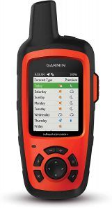
Display Size: 2.3 inches
Weight: 8 ounces
Battery Life: Up to 100 hours
Memory: 2 GB
Number of Waypoints: 500
Touchscreen: No
The Garmin inReach Explorer+ is one of the best backpacking GPS devices on the market – perfect for anyone who wants to escape into the wilderness, but not so much that they can’t be reached quickly.
What makes the Garmin inReach Explorer+ particularly special is its 100% global Iridium satellite coverage.
The Iridium network is the largest satellite network in the world with 75 satellites – its reach spans as far as the polar ice caps.
This means that you are truly never out of range, even if you’re far away from a cell tower or getting spotty reception.
Although you need a satellite subscription to get the most bang for your buck out of this feature, you can enable two-way texting from anywhere.
You can also turn on the tracking feature, allowing friends and family to know your whereabouts on the web-shared MapShare portal.
Another convenient feature of this Garmin backpacking GPS is that you can pair it with your phone (Apple or Android) via Bluetooth, so you can download maps, aerial imagery, U.S. NOAA charts, and even check the weather.
In case of an emergency, you can also send an interactive SOS to the 24/7 search and rescue monitoring center GEOS.
With this device, you’re able to communicate with them freely so they can notify the proper contacts and emergency responders in the area, ensuring that you’ll get help ASAP.
On top of the features mentioned above, this device comes with all the fun add-ons of a top-tier GPS device.
These include preloaded topo maps, a compass and barometric altimeter, and an accelerometer.
If you’re looking for solid GPS navigation for hiking, this is an ideal option.
It’s one of the best backcountry GPS trackers for those who want to get “lost” on a longer backpacking trip and can also be a great device for shorter hiking trips that are a little more rugged.
Or if you have more of a budget and you want another level GPS with satellite communication, another favorite to look at is the Garmin Rino 755t.
PROS
- The battery life is phenomenal, with up to 100 hours of juice at default 10-minute tracking mode
- The ability to send text messages from anywhere in the world without cell reception
- Your close ones can keep updated on where you are at any point during your trip
- You will get a GPS signal no matter where you are
- SOS access to a 24/7 search and rescue response center
CONS
- You’ll have to pay an activation fee to subscribe to one of the satellite coverage plans offered
- Texting on the interface is akin to texting in the pre-smartphone era
- Sending and receiving messages is not instantaneous. How long it takes for you to receive a message may depend on how close you are to one of the satellites
CHECK PRICE ON:
#3 Garmin eTrex 22x
Best Handheld GPS Under $200
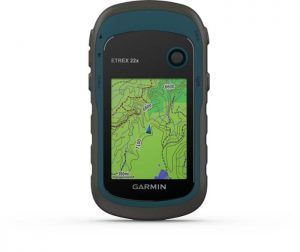
Display Size: 2.2 inches
Weight: 5 ounces
Battery Life: Up to 25 hours
Memory: 8 GB plus a microSD card slot
Number of Waypoints: 2,000
Touchscreen: No
If you’re new to hiking, you might experience trepidation at dropping a few hundred on a handheld GPS device.
After all, it’s such a niche machine for an activity that most people would consider a part-time hobby.
Surely your cell phone would suffice?
Luckily, there are more affordable options if you’re strapped for money but want that extra peace of mind while going on a hike.
The Garmin eTrex 22x is one of the best GPS devices for the money and a good entry-level option.
The biggest pros of the eTrex 22x include its tracking capabilities and the number of waypoints it can support.
These features make the eTrex22x very flexible when it comes to mapping out your hiking route, as you can leave multiple breadcrumbs and easily navigate your way through them.
In addition, the preloaded maps cover a lot of information you’d find useful on the trail, such as rest spots and places to fill up on water.
The eTrex 22x also supports viewing in different map formats (2D and 3D) and lets you upload coordinates.
If you want more detailed maps than the preloaded versions, you can usually find them on the Garmin site.
Lastly, the Garmin eTrex 22x is also well-suited for bike trips.
Because it has quality tracking capabilities, the eTrex 22x can easily follow along and measure your mileage on the trip.
If you’re looking for a cheap hiking GPS for your next outdoor adventure, this one is a good choice.
PROS
- Good at tracking where you’ve already hiked
- Good value – it’s a top hiking GPS device at an affordable price
- Sunlight-readable screen
- Can download GPX files to import maps
- Lightweight
CONS
- Smaller screen size
- The GPS interface isn’t as user-friendly as other devices
- You have to zoom in the maps enough to see the details on your route, but this can mean losing view of important landmarks
CHECK PRICE ON:
#4 Garmin Montana 680t
Best Handheld GPS With a Touchscreen
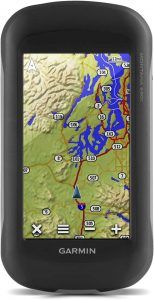
Display Size: 4 inches
Weight: 10 ounces
Battery Life: Up to 16 hours (lithium-ion), up to 22 hours (AA batteries)
Memory: 8 GB
Number of Waypoints: 4,000
Touchscreen: Yes
Now that smartphones have been around for more than a decade, going back to using an electronic device with buttons might not appeal to you.
Which is why it’s nice to have the option for touch-screen-compatible GPS devices these days.
This high-end Garmin Montana 680t shows that you don’t have to abandon your swipe-y and scroll-y ways.
You get visual galore with 100k+ preloaded topo maps of the U.S., along with a free year of the BirdsEye Satellite Imagery subscription.
The satellite imagery provides high-resolution detail so you get that extra oomph in your maps, and the sophisticated display lets you view the interface in dual orientation so you can see maps in rich detail and gain a better sense of the topography.
These details make it the perfect GPS for hiking trails or backcountry explorations around the U.S.
It also has a decent internal memory with the ability to hold up to 4,000 waypoints, 10,000 track points, and 200 saved tracks.
To keep all of these tracks organized, the Montana GPS unit has a track manager – a quick and easy way to organize and navigate through all your routes, track logs, and waypoints.
Similar to other devices on this list, the Montana 680t has a 3-axis compass and barometric as well.
Pair this with a high-sensitivity receiver, Hotfix satellite prediction, and GPS and GLONASS support, and this device can pinpoint your current location quickly (even in heavy cover).
If you’re looking for a versatile GPS device that can “do it all,” the Montana 680t might be it.
And if you’re ready to spend extra for the Montana 700 series, you’ll enjoy updated features like two-way satellite messaging and dog tracking. The Garmin Montana 700i and Montana 750i take this GPS unit to the next level.
You can take this personal GPS tracker hiking, snowmobiling, geocaching, or wandering through the forest while staying high-tech and rugged at the same time.
PROS
- A massive touch screen display clocking in at the largest of our recommendations.
- An 8 MB autofocus camera that automatically geotags your photos
- Glove-friendly (so you don’t have to worry about frostbitten fingers while using the Montana in the snow)
- Comes with 250,000 preloaded geocaches worldwide for all you geocaching fans out there
CONS
- On the pricier side, costing $430 – not including add-ons like a screen protector
- Although it’s water-resistant, the touch screen is harder to use when it’s wet
#5 Garmin Oregon 700
Best Handheld GPS for Beginners
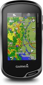
Display Size: 3 inches
Weight: 8 ounces
Battery Life: Up to 16 hours with 1 lithium-ion battery
Memory: 3.5 GB
Number of Waypoints: 10,000
Touchscreen: Yes
If you don’t want to spend money on a kitted-out touchscreen device like the Garmin Montana 680t or Garmin Montana 700 series, the Garmin Oregon 700 is a beginner-friendly and cheaper touchscreen alternative in the GPS device market.
While other articles might recommend, the newer Oregon 750t, I still think you get the best bang for your buck with the Oregon 700.
The Oregon 750t costs an extra hundred dollars and distinguishes itself with a built-in camera (no better than your phone camera) and flashlight.
Probably the best thing about the Oregon GPS units as a whole is the ease of use, with its touchscreen interface being straightforward to navigate.
While more veteran hikers might prefer the presence of physical buttons, the touch screen on the Oregon 700 is well-suited for casual hikers that are looking for a straightforward design with simple features.
This device has the ABC of sensors – an accelerometer, barometric altimeter, and 3-axis compass – to ensure that you can pinpoint your location and waypoints as accurately as possible.
One interesting feature of this GPS device that you don’t see in many others is its activity profiles.
Whether you’re biking, hiking, fishing, or geocaching, you can select these activity profiles to automatically generate a customized interface for what you’re doing.
This takes a load off of users who are just trying to familiarize themselves with how they can use a GPS device without having to painstakingly customize features to all the different activities they do.
Another unique feature of the Oregon 700 is Connect IQ.
Connect IQ allows you to customize your device with data fields, widgets, and apps of your own design.
This is a huge departure from most GPS devices, which lose out in customization in favor of pushing their own features and services.
Overall, the Garmin Oregon 700 is one of the best GPS trackers for hiking if you’re new to using GPS and you just want something that’s easy to use.
PROS
- Affordable
- Plenty of storage for waypoints and maps
- Wireless messaging
- Simple and customizable interface
- Easy to use and great for beginners or those who want a straightforward device
CONS
- Battery life drains quickly with the touch screen functionality
- Doesn’t like the cold weather – can freeze-up
#6 Garmin eTrex 10
Best Handheld GPS for Geocaching and Hiking
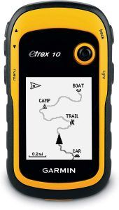
Display Size: 2.2 inches
Weight: 5 ounces
Battery Life: 25 hours; AA batteries required
Memory: 6 MB
Number of Waypoints: 1,000
Touchscreen: No
The best GPS for geocaching and hiking, the Garmin eTrex 10 is a beloved classic and it’s not hard to see why.
Beyond its eye-popping yellow casing (which means it’d be hard to lose, even at night) and rugged design, it comes at an affordable price point.
If you’re not looking to invest too much and you want a simple handheld GPS, the eTrex 10 is perfectly capable of doing what you need it to do: pinpoint your location and endpoint and map out waypoints in between.
Tracking is automatic and takes up little internal memory.
Plus, the eTrex 10 supports geocaching GPX files for transferring geocaches, making this device one of the best in the geocaching game.
It can display valuable information like difficulty level, hints, terrain, and more so you can effectively geocache without needing paper.
The eTrex series is also the first to track GPS and GLONASS satellites at the same time.
This allows for accurate pinpointing as well as faster readings since the eTrex10 now has access to 24 more satellites than just the GPS network.
However, the eTrex 10 does not come with additional maps beyond its basic worldwide map, and its screen is not big enough to show terrain maps in great detail.
As a result, you should consider buying the eTrex 10 as additional support for your compass and map rather than as a standalone device.
PROS
- Affordable
- Decent battery life
- Lightweight
- Can track GPS and GLONASS satellites at the same time
- Good for geocaching
CONS
- Monochrome color display
- On its own, it’s probably not sufficient as a survival tool (you’ll want to bring another compass and map with you)
- Low amount of storage
CHECK PRICE ON:
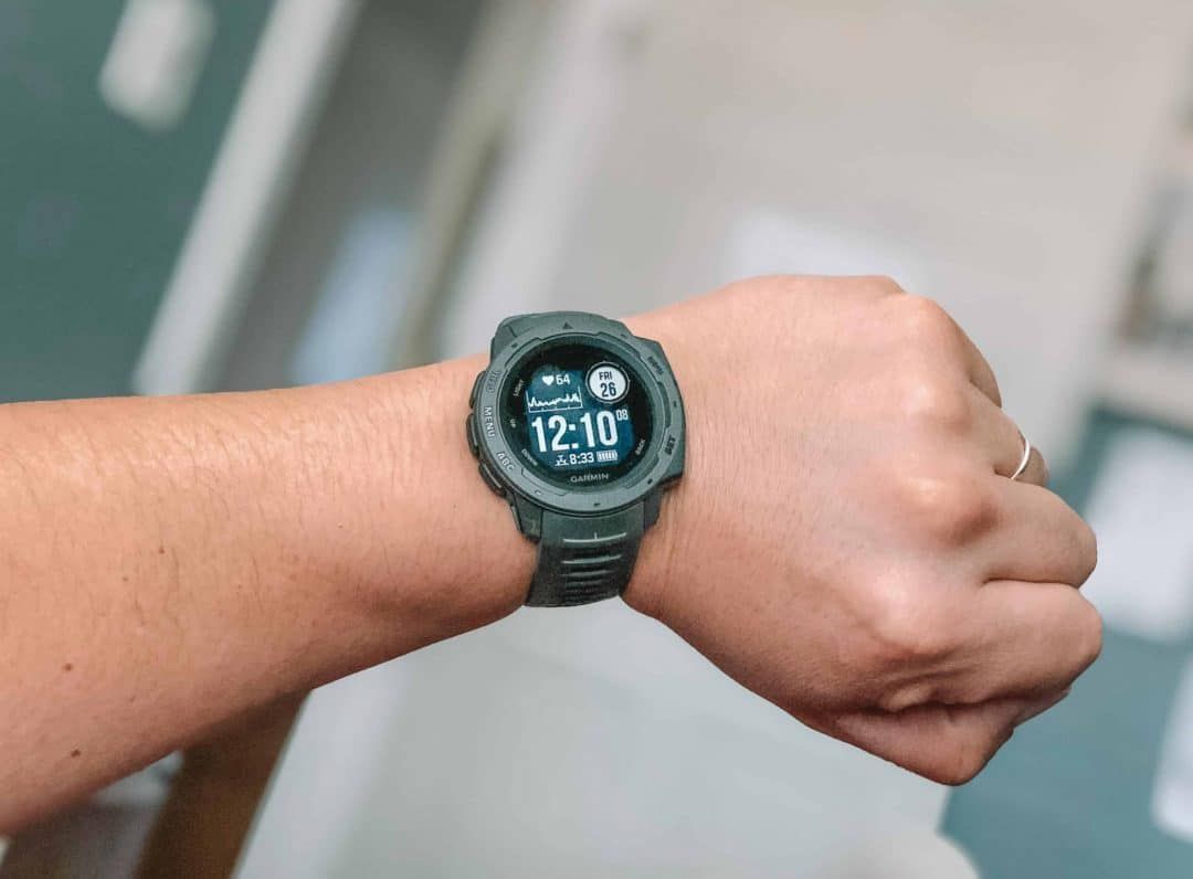
#7 Garmin Instinct 2
Best GPS Watch for Hiking
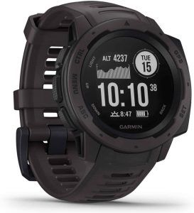
Weight: 1.76 ounces
Battery Life: Up to 14 days in smartwatch mode, 16 hours in GPS mode, and 40 hours in Ultratrac battery saver mode
The best Garmin hiking watch on the market these days, the Garmin Instinct 2 packs a lot of punch into a small watch.
While GPS watches may not have the same rugged cachet or robust functionality as a handheld device might, there’s no denying that Garmin makes some of the most practical GPS watches on the market today.
The Garmin Instinct watch is a prime example of being tough yet super functional, keeping your hands free to carry other things.
GPS watches ultimately have to sacrifice utility in favor of being more portable, but they still have a lot of versatility.
Most notably, they’re able to take inspiration from other smartwatches and tack on features that your traditional handheld GPS wouldn’t be able to provide.
For instance, this Garmin watch can monitor your heart rate, activity, and stress.
You can also connect this watch to your smartphone to get notifications delivered to your wrist.
And you can connect to the Garmin Connect Online community through your smartphone to get automatic updates, live tracking, and the GroupTrack feature.
But these features are all just a bonus to an already strong GPS device.
The Garmin Instinct watch taps into GPS, GLONASS, and Galileo networks, ensuring that the satellite tracking is top-notch.
And the barometric altimeter and 3-axis compass round out the package.
If you’re looking for the best GPS watches for hiking, the Garmin Instinct is one of the best on the market right now.
Read our complete guide to the best outdoor watches.
PROS
- 3-pronged satellite network for robust tracking
- Heart rate, stress, and activity (including sleep) monitor to help you train
- Easy smartphone pairing and connection to an online community
- Comes in 20 different colors
CONS
- The buttons on the bottom jut out, so you might end up bumping them if you’re doing a lot of hands-on work
- Hard to tell which buttons are for which functions (unless you’re in bright sunlight)
- Screen size could be bigger
CHECK PRICE ON:
#8 Garmin Forerunner 245
Best GPS Watch for Running and Hiking
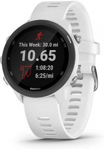
Weight: 1.28 ounces
Battery Life: Up to 7 days in smartwatch mode; up to 6 hours in GPS mode with music
If you’re wondering who the Garmin Forerunner 245 was built for, it’s in the name.
Trail runners who are looking for a powerful smartwatch and one of the best outdoor GPS watches that can track your position and activity at the same time, should look no further than the Garmin Forerunner 245.
While this watch may not be the best suited for activities like strenuous treks, it’s ideal for people who want to put on serious speed or customize workout plans that upload directly to the interface.
The analytics on this watch is one of the top reasons why the Garmin Forerunner is a winner.
Not only can it calculate your VO2 max, but you can also detect at what altitude and temperature your VO2 max is being impacted.
This allows for a truly customized report that can inform your training and rest plans.
It will also analyze your running form, including cadence, stride, ground contact, and more so you can optimize for better trail running performance.
In addition, you can upload custom routes that give you directions while running, track your sleep, and even detect your blood oxygen levels.
This watch is also perfect for runners who love jamming out to music on their route.
It can pair up with music streaming apps like Spotify so you can easily stream your favorite songs into your headphones – perfect for that morning jog on the mountain trails.
The design itself is sleek and sporty, promising ease of use without skimping on the features.
And the crisp, hi-res screen makes it all the more pleasant to use the watch as you’re about to go on another training session.
If you want to step up your trail running game and you have the extra budget, the Garmin Forerunner 945 is another good alternative for runners and hikers.
PROS
- Robust features with easy navigation
- You can load workout plans, custom routes, and training plans
- Waterproof
- Can use with headphones to listen to music while you wear it
- Advanced running tracking and analytics
CONS
- The battery life isn’t fantastic, so this watch will require regular charging
- Doesn’t have a barometric altimeter
- Spotify and Deezer services require a premium membership to sync
CHECK PRICE ON:
FAQ: More Questions and Tips for Buying a GPS for Hiking and Backpacking
Is Garmin Better than TomTom?
In all honesty, Garmin and TomTom both have their strengths and weaknesses.
You won’t find a product from either brand that is going to do everything perfectly.
However, if you were to use similar products from either brand side-by-side, you would generally find that:
- The Garmin hiking GPS interface and navigation tend to be easier and more intuitive to use than TomTom.
- TomTom can sometimes be quicker to get GPS readings than Garmin.
- Garmin has better maps for the U.S., while TomTom has better maps for Europe. However, both brands have excellent maps for both continents, so it’s better to make sure that you have the latest versions of the maps downloaded.
What is the Best GPS for Hiking the Appalachian Trail?
The Appalachian Trail is 2,190 miles long, and a typical thru-hike takes 5-7 months.
That means you’re either going to want a GPS watch that can withstand such a long trek and has a good battery life, and preloaded POIs so you can figure out which rest stops to visit.
Thankfully, the Appalachian Trail is well-traveled and documented, so you don’t have to worry too much about getting lost on the trail.
That said, it’s a long journey so you’ll want to make sure you can communicate in case of an emergency.
Keeping all of these requirements in mind, either the Garmin inReach Explorer+ or the Garmin Montana 680t are your best bets.
They both have reliable signals and decent battery life, but the inReach Explorer+ is the better option if you need to send a message in a pinch.
What is the Best GPS for Hiking Europe?
If you’re hiking in Europe, chances are you’ll still be relatively near a cell tower or an urban environment, so you don’t need to worry as much about signal reliability.
Instead, a GPS device that has more detailed maps might be more beneficial.
In that case, the best GPS for Europe would be the Garmin GPSMAP 67i.
Even though it comes with preloaded maps of North America, it can support TopoActive maps, including the Garmin TopoActive Europe map.
It also has a lot of space available for storing waypoints and tracks, which is perfect for documenting scenic places in Europe.
Like the idea of a GPS watch? Read our guide to the best Garmin watches for women.
Conclusion: Our Top Pick for the Hiking GPS Devices
Out of the eight recommendations listed above, what is the Best Garmin GPS for Hiking? My top choice is the Garmin GPSMAP 67i.
The Garmin GPSMAP 64csx has highly accurate readings and built-in maps with POI, which allow users to identify the best routes to take depending on their needs at the time.
This is hands down one of the best Garmin GPS devices for hiking. But if it’s not in your budget these are my other favorites:
- Garmin eTrex10: For its quick and accurate pinpointing, using both the GPS and GLONASS network at an affordable price.
- Garmin Instinct 2: For being a well-priced Garmin hiking watch with a robust design, GPS, GLONASS, and Galileo satellite network capability, and a barometric altimeter.
- Garmin Forerunner 245: For being able to record your physical performance while incorporating hikes into your workout regimen. This is the best entry-level Garmin watch for hiking and running.
ABOUT THE AUTHOR

Mimi McFadden
Founder & Editor-In-Chief
Mimi McFadden initially started The Atlas Heart in 2013 to write about her adventures abroad. But since 2019, The Atlas Heart has become a love letter to the Golden State. Mimi enjoys sharing her first-hand knowledge and expertise with the places she knows so well and making the most comprehensive travel guides possible. When she’s not hiking and exploring new places in California, she loves to travel abroad, read in her cozy chaise lounge, play basketball, and connect with friends and family over board games. Over her 28 years in California, she has lived in Santa Cruz (18 years), San Diego (5 years), and the San Francisco Bay Area (5 years), where she currently resides.
Looking for more posts on the best outdoor gear? Check out these related posts below!
Best Dog Backpack Carriers for Hiking
Best Waterproof Walking Shoes for Women
Best Heated Gloves for Cold Weather
Best Compact Binoculars for Outdoor Activities
11 Best Backpacking Rain Ponchos
Pin one of these images for future reference

